What is a climate diagram?
|
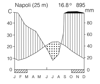
On a climate diagram, the location, mean annual temperature, and annual precipitation are presented on top.
|
A climate diagram is a visual representation of the climate at a location and was developed by the German ecologist Heinrich Walter. In a climate diagram, the mean monthly temperature is plotted using the scale on the left. The mean monthly precipitation is plotted using the scale on the right, using a scale twice in value relative to the temperature y-axis scale.
When the precipitation exceeds the temperature, then it is a "humid" period favorable to plant growth. When the temperature exceeds the precipitation, then it is a "drought" period and unfavorable for plant growth. Humid periods are denoted by vertical stripes, whereas drought periods are denoted by stippling. Extreme humid periods are denoted with a solid black line. A climate diagram forms a "gestalt climate" image recognizable across geographic locations and easily allowing for climate comparisons. |
